Contents
Questo articolo è disponibile anche in:
Various and numerous are the stories that, over the centuries, have been told about the so-called “ghost islands”: places that once existed, now disappeared from every geographical map; or again, fictitious places, rendered so well by their authors as to seem almost real. But one of the most curious cases of the geography of the Pacific Ocean is certainly Sandy Island.
This strip of land, firstly observed in the eighteenth century during the expeditions carried out by Captain James Cook, has aroused the curiosity of the whole world over the years. It was, in fact, represented in geographical maps up to the contemporary era, but reality it is unobtainable not only to the eyes of cartographers, but also to the “electronic eye” of the most modern satellites. What could it be about then? And what was the role of France in its “undiscovery”?
The first observations of Sandy Island
From the discovery of America onwards, the era of great discoveries begins: the world is wider than what, until then, had been known. Many embarked towards the unknown, and great were the surprises that the explorers found themselves in front of.
It was Vasco Núñez de Balboa, a Spanish explorer in search of a legendary land full of riches, who observed the “South Sea” for the first time, not knowing that it was the largest water expanse on Earth: the Pacific Ocean, whose current name was given later by Ferdinand Magellan, given the simplicity of navigation in its waters.
The second half of the eighteenth century is certainly linked to the name of the British captain James Cook, and to his three voyages across the Pacific Ocean, with the aim of discovering and mapping new territories that had escaped the explorers who came before him. His journey gave the possibility to map numerous new territories, from New Zealand to Hawaii, giving a very important contribution to the cartography produced up to that moment.
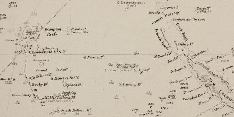
During the second of his three voyages, exactly between 14 and 15 September 1774, Cook reported a new island on his map: Sandy Island, located near New Caledonia. A not very large strip of land, which from that moment on was represented on all nautical charts, until the end of the nineteenth century.
However, already a century after Cook’s mapping, a whaler, the Velocity, noticed that, in the locality marked by the English captain, there were big waves breaking on sandy islets, but there was no sign of what should have been Sandy Island. It didn’t take long, therefore, before the geographical maps began to mark this place as “E.D.”, “existence doubtful”: the important thing, however, was to warn sailors of a potential danger.
From detections to the “undiscovery”
More recently, in the 20th century, the mystery of Sandy Island was solved. A particular interest was shown by France: being, according to what Cook mapped, close to New Caledonia, the island would have been among the French possessions. For this reason, the SHOM (service hydrographique et océanographique de la Marine), after carrying out some surveys over the area, decided to remove the island from the geographical maps.
This “non-existence thesis” was confirmed by the Australian Hydrographic Service which, scanning the seabed of the area, not only confirmed the absence of the island, but also the depth of the sea in the surroundings: from 1400 to 2400 m. Thus, Sandy Island was “undiscovered”: although it was present on Google Maps until recent years, now, looking for its coordinates, a “trace” can be noticed, like something that has been cancelled.

The hypothesis on the existence of the island
After such a denial, however, many questions remain. Could James Cook have made such a big mistake? Or did Sandy Island really exist, at some point in history, and then disappeared completely? The most probable hypothesis is that Cook, as well as the Velocity, may have spotted a pumice stone “raft”, the result of an underwater eruption that occurred, at the time, in the vicinity of its position.
Cook’s mistake may therefore have been genuine: such floating objects resemble land in all aspects, with the presence of sand in the tidal area and, sometimes, animals. The presence of the latter, among other things, would explain, according to the biologists, the migration of certain species from one land to another, thanks to the movement of these “rafts”. Sandy Island, however, remains a ghost island: the most curious “undiscovery” in the history of the exploration of the Pacific Ocean.
Stay up to date by following us on Telegram!


